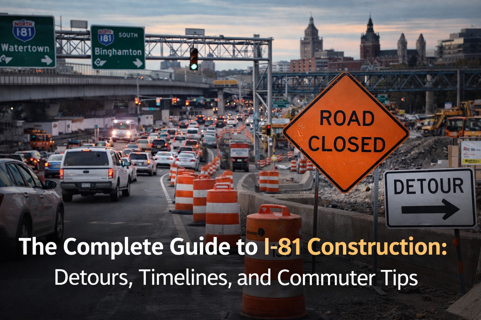
The Biggest Infrastructure Project in Syracuse History Is Underway. Here’s What You Need to Know.
For decades, the I-81 viaduct was the defining feature of Syracuse’s skyline — a mile-long elevated highway cutting through the center of the city, carrying 98,000 vehicles per day over the neighborhoods it divided. Now it’s coming down. The New York State Department of Transportation’s community grid project is the largest infrastructure undertaking in Syracuse’s history: a $2.25 billion demolition and reconstruction that will reshape how every single person in this metro area gets from point A to point B for the next several years.
Whether you commute through downtown, live in the affected neighborhoods, or just need to get across town without losing your mind, this guide is your reference. We’ll update it as conditions change — bookmark it and check back.
What’s Actually Happening: The Project in Plain English
The elevated section of I-81 that runs through downtown Syracuse — from roughly the I-690 interchange on the north end to the Martin Luther King East neighborhood on the south — is being demolished and replaced with an at-grade urban boulevard. Through-traffic that currently uses I-81 to pass through Syracuse will be rerouted onto I-481, which will be redesignated as the new I-81.
The old I-81 corridor through the city will become a surface street called the “Community Grid” — essentially a redesigned version of Almond Street with improved intersections, pedestrian infrastructure, and connections to the surrounding neighborhoods that were cut off when the original highway was built in the 1960s.
This isn’t just a road project. It’s a fundamental reshaping of Syracuse’s urban core. The neighborhoods east of the highway — the 15th Ward, University Hill, the Near East Side — have been physically separated from downtown for over 60 years. The grid is supposed to fix that.
A Brief History: How We Got Here
The original I-81 viaduct opened in 1969. It was part of the federal interstate highway program that plowed through urban neighborhoods across America, and Syracuse’s experience was typical of the era: the construction demolished most of the 15th Ward, a thriving Black neighborhood, displacing an estimated 1,300 families and dozens of businesses.
By the 2000s, the viaduct was structurally deficient. Federal bridge inspectors flagged deteriorating concrete, corroded rebar, and load-bearing concerns. NYSDOT began studying replacement options in 2011, and the debate consumed Syracuse politics for over a decade. Three options emerged: rebuild the elevated highway, dig a tunnel, or tear it down and build the community grid. Governor Hochul approved the grid option in 2022, and demolition prep began in 2023.
The viaduct’s main span came down in phases through 2024 and into 2025. As of early 2026, most of the elevated structure between the I-690 interchange and Adams Street has been removed, and construction on the at-grade boulevard and utility relocation is in full swing.
Current Phase: What’s Closed and What’s Open (Updated March 2026)
Closed:
- I-81 northbound and southbound through downtown Syracuse between Exit 16 (Brighton Avenue / South Salina Street) and Exit 18 (Adams Street / Harrison Street). This is the core demolition zone.
- The Almond Street on/off ramps at East Genesee Street and East Adams Street.
- The Pearl Street exit (formerly Exit 17) — permanently eliminated as part of the grid design.
- Portions of East Adams Street between Almond and Townsend are intermittently closed for utility work.
Open with restrictions:
- I-690 through downtown remains open in both directions, but lane reductions and shifting patterns are constant. Expect delays of 10-20 minutes during peak hours.
- South Salina Street through the construction zone is open but narrowed to one lane in each direction south of East Adams.
- University Avenue between East Genesee and Comstock Avenue is open but has flagging operations during work hours (7 a.m. to 5 p.m. weekdays).
Detour Routes: Street-by-Street Breakdown
Here’s how to get where you’re going while the core of I-81 is closed.
Northbound Through-Traffic (Coming from Binghamton / Cortland, Heading to Watertown / North)
If you’re just passing through Syracuse on I-81 and don’t need to stop downtown:
- Take I-481 North from the I-81/I-481 split south of Syracuse (near Nedrow).
- Follow I-481 as it loops east around the city through DeWitt and East Syracuse.
- Merge back onto I-81 North at the I-481/I-81 junction north of Cicero.
- Total added distance: about 12 miles. Added time: 10-15 minutes in normal traffic.
Southbound Through-Traffic (Coming from Watertown, Heading to Binghamton / PA)
Reverse the above: take I-481 South from the northern split near Cicero, loop east through Kirkville and DeWitt, and rejoin I-81 South near Nedrow.
Downtown Access from the South (Nedrow / Valley / LaFayette)
This is where most commuters feel the pain. The old route — I-81 North to Exit 17 or 18 — is gone. Here are your options:
- Route A (South Salina Street): Exit I-81 at Exit 16 (Brighton Ave). Turn right onto Brighton, then left onto South Salina Street. Follow South Salina straight into downtown. This is the most direct route but gets congested between 7:30-9:00 a.m.
- Route B (South Avenue): Exit I-81 at Exit 16, take Brighton Ave west to South Avenue. North on South Avenue through the Valley and Strathmore into downtown via Onondaga Street. Less traffic than South Salina, adds 3-4 minutes.
- Route C (Colvin Street): For University Hill destinations (hospitals, SU), exit at Exit 16, take Brighton to Colvin Street east, then north on Comstock Avenue to campus. Avoids downtown entirely.
Downtown Access from the North (Liverpool / Cicero / Clay)
- Route A (Hiawatha Boulevard): Exit I-81 at Exit 23 (7th North Street). Take 7th North to Hiawatha Boulevard, then follow Hiawatha west into downtown via the Bear Street / Salina Street intersection. Works well for Armory Square, the Civic Center, and west downtown.
- Route B (Teall Avenue / James Street): For east-side destinations and University Hill, exit I-81 at Exit 22 (Teall Avenue). South on Teall to James Street, west on James into downtown or south on Beech Street to the university area.
- Route C (I-690): Stay on I-81 South to the I-690 West interchange. Take 690 to the State Street exit (Exit 13) or the West Street exit (Exit 11). Best for west downtown, Tipperary Hill, and Armory Square.
East-West Crosstown
Getting across the construction zone east-west is one of the biggest daily headaches:
- North crossing: Use Erie Boulevard (runs parallel to I-690, relatively clear).
- Central crossing: East Genesee Street still connects the east side to downtown, but expect delays near the Almond Street intersection. East Fayette is a decent alternative one block north.
- South crossing: East Colvin Street to South Salina via Comstock and Lancaster. It’s longer but avoids the worst of the construction zone.
Project Timeline: Key Milestones
| Phase | Timeframe | What’s Happening |
|---|---|---|
| Phase 1 | 2023-2024 | Utility relocation, ramp closures, demolition prep. Completed. |
| Phase 2 | 2024-2025 | Viaduct demolition (main span). Substantially complete. |
| Phase 3 | 2025-2026 (current) | Community Grid boulevard construction, intersection buildouts, new utility infrastructure under the former highway footprint. |
| Phase 4 | 2026-2027 | Grid boulevard opens in stages. New intersections at Almond/Genesee, Almond/Adams, and Almond/Harrison come online. Streetscaping and pedestrian infrastructure. |
| Phase 5 | 2027-2028 | Finish work: final paving, signal optimization, park construction on reclaimed land, landscaping. I-481 officially redesignated as I-81. |
NYSDOT’s current estimate for “substantial completion” is late 2028, but the boulevard is expected to be driveable in stages starting in mid-2027. The realistic expectation among transportation planners and city officials is that full completion — including all the park space, streetscaping, and final punch-list items — stretches into 2029.
Centro Bus Routes: A Real Alternative
If you’ve never taken the bus in Syracuse, now might be the time to try it. Centro has adjusted several routes to serve commuters affected by the construction:
- Route 20 (South Salina): Runs every 15 minutes during peak hours from Valley Plaza to the Hub at Salina and Fayette. Roughly 25 minutes end to end.
- Route 62 (University Hill): Connects the Hub to SU campus and Crouse Hospital via Harrison and Irving. Every 20 minutes peak, 30 minutes off-peak.
- Route 48 (Eastwood / James Street): Connects Eastwood to downtown via James Street, avoiding the construction zone entirely. 20-minute headways peak.
- Syracuse University Connective Corridor: SU runs its own shuttle from the Warehouse District on West Fayette up to campus. Free for SU/ESF students and staff, and it avoids the worst construction pinch points.
Centro’s fare is $2.00 cash or $1.60 with the Centro Go mobile app. Monthly passes are $56 — for a daily commuter, that’s cheaper than parking downtown ($120-180/month at most garages).
Park-and-Ride Options
- Destiny USA lot (north side): Free parking in the east lot. Catch Route 30 or 44 to downtown. 10-minute ride.
- Valley Plaza (south side): Free parking. Route 20 to downtown. 25 minutes.
- ShoppingTown (DeWitt): Free parking in the former mall lot. Route 62 to University Hill. Infrequent service — check Centro schedules.
- Mattydale Park-and-Ride (Route 11): Small lot off Northern Boulevard. Route 80 to downtown. 15 minutes.
Tips from People Who Commute Through This Every Day
We asked CNY Signal readers and local commuters for their real-world advice. Here’s what works:
- Leave 20 minutes earlier than you think you need to. Seriously. The detours aren’t that much longer in distance, but signal timing on surface streets makes the time unpredictable.
- Avoid the 7:45-8:30 a.m. window on South Salina. That’s when southside commuters, hospital workers, and SU traffic all converge. If you can shift your start time by even 15 minutes, it makes a difference.
- Use Waze or Google Maps in real-time. Construction staging changes week to week, and what was a good route on Monday might be flagged on Tuesday. Let the algorithm figure it out.
- Colvin Street is underrated. If you’re headed to University Hill from the south side, Colvin to Comstock to campus is usually faster than going through downtown and backtracking up the hill.
- The I-690 West-to-State-Street exit backs up after 5 p.m. If you’re leaving downtown headed west, take West Street to Geddes Street instead of fighting the 690 on-ramp at Crouse Avenue.
- Bike it if you can. The Onondaga Creekwalk from the Inner Harbor to Armory Square is a car-free commute path that completely avoids the construction. It’s about a 20-minute ride from the north side neighborhoods.
Impact on Businesses and Neighborhoods
The construction has hit some businesses hard. Restaurants and shops along South Salina between Adams and Colvin have reported customer drops during peak construction phases when their storefronts were behind jersey barriers. The Syracuse Industrial Development Agency approved tax relief packages for some affected businesses in 2025, but not everyone qualifies.
On the flip side, real estate interest in neighborhoods adjacent to the future grid — particularly the Near East Side and South Side — has ticked up. Developers are betting that once the boulevard is complete, the reconnected street grid will make these areas more walkable and desirable. Early signs support that theory: commercial lease inquiries along the future grid corridor are up 40% compared to pre-project levels, according to the Syracuse Downtown Committee.
How to Stay Updated
Construction schedules shift frequently. Here’s where to get reliable, current information:
- CNY Signal Roads Dashboard: We pull real-time 511NY data and NYSDOT alerts into a single view showing current road conditions, closures, and construction impacts across the metro.
- NYSDOT I-81 Project Website: dot.ny.gov/i81opportunities — official project updates, construction schedules, and public meeting notices.
- NYSDOT Text Alerts: Text “81SYRACUSE” to 51555 for weekly construction updates direct to your phone.
- Centro Route Alerts: centro.org/alerts for any bus route changes due to construction staging.
This guide will be updated as phases progress, new detours are implemented, and the grid starts coming online. If you spot something that’s changed or have a commuter tip we missed, let us know at cnysignal.com.