New York recorded confirmed harmful algal blooms in 30 waterbodies across six Central New York counties last year, the most since the state began tracking them in 2019. Most blooms are first reported in August, and the state’s dataset does not yet include 2026.
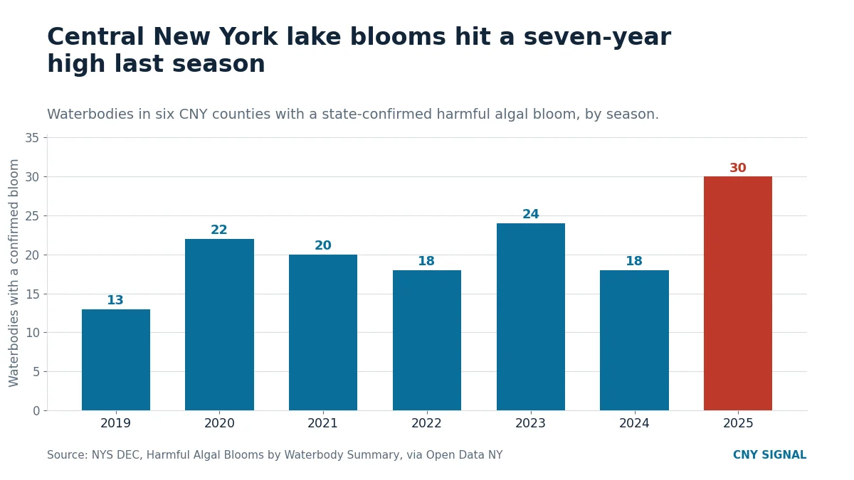
Thirty waterbodies across six Central New York counties had a confirmed harmful algal bloom at some point during the 2025 season, according to state Department of Environmental Conservation data. That is the most of any year since New York started tracking blooms by waterbody in 2019, and a jump from 18 waterbodies in 2024. The previous high, in 2023, was 24.
This story came from public records we pulled ourselves
Get the next one, plus overnight incidents, in your inbox at 6 AM. Free, no spam.
The count comes from “Harmful Algal Blooms by Waterbody Summary,” a DEC dataset published through New York’s open data portal that logs confirmed bloom reports by lake, river or pond, back to 2019. The dataset runs through the 2025 season and does not include anything from 2026. Anyone who wants to know whether a specific lake has a bloom right now needs to check the state’s live interactive map, at on.ny.gov/nyhabs, not this dataset.
A seven-year climb, then a jump
Year by year, the number of waterbodies with a confirmed bloom across Onondaga, Cayuga, Oswego, Madison, Cortland and Oneida counties: 13 in 2019, 22 in 2020, 20 in 2021, 18 in 2022, 24 in 2023, 18 in 2024, and 30 in 2025. This past season’s total beat the old high by 6 waterbodies, the biggest single-year jump in the seven-year record.
Those 30 waterbodies produced 206 individual confirmed bloom reports over the course of the season, and the reports were not spread evenly.
Owasco Lake led the region, and supplies Auburn’s water
One lake accounts for nearly half the region’s reports by itself. Owasco Lake, in Cayuga County, had 96 confirmed bloom reports in 2025, with the first dated July 28 and the last October 28, more than double the next-closest waterbody. Otisco Lake, in Onondaga County, had 43 reports, from late June through mid-September. After that the counts drop off fast: North Sandy Pond in Oswego County had 11, Owasco Outlet had 8, and Jamesville Reservoir had 5. Twenty-five more waterbodies across the six counties logged between 1 and 4 reports each.
Owasco Lake is not just any lake. DEC’s own page on Owasco Lake says the lake is a drinking water source for the City of Auburn and the Town of Owasco, and is classified AA(T) as a result, the state’s designation for a protected water supply. Auburn treats and filters its water before it reaches taps. But the lake feeding that treatment plant was the most bloom-affected waterbody in the region in 2025, by a wide margin.
The lake that isn’t on this list
Skaneateles Lake, the drinking water source for the City of Syracuse, does not appear anywhere in the 2025 CNY bloom data. That is worth pointing out because Skaneateles Lake is unusual: Syracuse does not filter the water it draws from the lake. The city operates under a waiver from the state health department that allows it to disinfect with chlorine instead of running the water through a filtration plant, subject to strict conditions, according to the Onondaga County Water Authority. A confirmed bloom would matter more on an unfiltered supply than a filtered one, which is part of why Skaneateles Lake’s clean record in this dataset stands out next to Owasco Lake’s crowded one.
When blooms happen
Pooling every confirmed bloom’s first-report date across all seven years of CNY data shows a clear pattern. Two reports came in May and one in February, but the season builds through June, with 33 first reports, and holds through July, also 33. August is the single busiest month, with 45 first reports, about 31 percent of every first sighting in the seven-year record. September is second, with 25. Combined, August and September account for 70 of the 145 pooled first reports, just under half. After that, the season fades fast: 5 first reports in October, 1 in November.
A first report is not the same as an ending, either. Several 2025 blooms ran well past the month they started. Owasco Lake’s first 2025 report came July 28; its last dated report was October 28. Lake Moraine, in Madison County, was first reported July 10, with a report as late as November 9. Cazenovia Lake was not reported at all until September 29, and had a report as late as November 2.
What the state says to do near a bloom
DEC’s guidance is direct: avoid swimming, boating or otherwise recreating in water with a bloom, and do not drink it. Pets face a faster, more serious risk. A dog exposed to a bloom can show stumbling, seizures, convulsions or paralysis within 30 minutes to hours, and DEC advises rinsing an exposed pet with clean water and getting it to a veterinarian right away. In people, exposure can bring on vomiting, nausea, diarrhea, skin or eye irritation, or breathing trouble.
The strongest warning applies to drinking water. DEC says never to drink, cook, prepare food or make ice with untreated surface water during a bloom, and that home treatments including boiling, chlorine, ultraviolet light and standard filtration do not protect against the toxins some blooms produce. That guidance is aimed at people drawing water from a private well or intake near an affected lake, not at customers of a treated municipal system like Auburn’s or Syracuse’s.
New York’s current conditions map, at on.ny.gov/nyhabs, is the state’s tool for checking whether a specific lake has a bloom today. The season summarized here ended in 2025. The state has not yet published anything for 2026.
Sources
- Harmful Algal Blooms by Waterbody Summary: Beginning 2019, NYS Department of Environmental Conservation via Open Data NY, dataset 95my-wijm. https://data.ny.gov/d/95my-wijm
- Harmful Algal Blooms information page, NYS Department of Environmental Conservation. https://dec.ny.gov/environmental-protection/water/water-quality/harmful-algal-blooms
- Owasco Lake waterbody page, NYS Department of Environmental Conservation. https://dec.ny.gov/nature/waterbodies/lakes-rivers/owasco-lake
- Sources of Water, Onondaga County Water Authority. https://www.ocwa.org/about/sources-of-water/
- New York HABs current conditions map, NYS Department of Environmental Conservation. https://on.ny.gov/nyhabs
Every figure in this story is drawn from the records above. Links go to the primary documents.